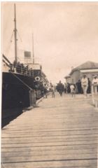
“The country north of Auckland may be most conveniently reached by taking passage in one of the Northern Steamship Company’s fine vessels which, leaving Auckland in the late afternoon, reaches early the following morning the expansive estuary of the Bay of Islands lying between Capes Wiwiki and Brett, eleven miles apart. So spacious is the entrance, and so deep is the water – so free from hidden dangers – that one may enter at will any time and anchor close up to the lovely shores without risk of stranding. It is, in truth, one of the finest harbours in the world…Steaming up the capacious inlet – wherein the navies of Europe may ride in safety – the vessel passes in rapid succession pretty little isles verdurous with foliage and serene in their unbroken repose, while the coast on either side is replete with the unpremeditated embellishments of Nature – sequestered bays, pebbly beaches, ferny dells, woody knolls, and clustering hamlets. While the charms of the bay and its hundred isles hold the attention the vessel rounds a rocky peninsula redundant with vegetation, and directly in her course lies the town of Russell slumbering on the margin of its delightful crescent-shaped bay… as we wander about the streets we tread upon the ashes of Kororareka – of that strange Alsatia of the Pacific where runaway convicts from Australia consorted with hardy whalers, and where nightly orgies and daily brawls disgraced the name of civilisation. At times as many as one hundred and twenty whalers have lain together off its beach, and money was freely spent and little regarded there.” This is how our town and surroundings were perceived in an 1886 publication by a writer who arrived by sea, possibly in the ship shown in the photo, the NSSCo’s Clansman. Here it is tied up to the Russell wharf, on a Friday night c.1920, loading passengers for Auckland .
Source: Picturesque Atlas of Australasia Vol III. pp64-65. Edited by Hon, Andrew Garran. 1886


